Floodplains
A river, stream, lake, or drain may on occasion overflow their banks and inundate adjacent land areas. The land that is inundated by water is defined as a floodplain. Go to our Floodplain page to learn more.
 Most people are familiar with the cattail or lily pad wetland found in areas with standing water, but wetlands can also be grassy meadows, shrubby fields, or mature forests. In fact, many wetland areas may not have any standing water visible. Types of wetlands include deciduous swamps, wet meadows, emergent marshes, conifer swamps, wet prairies, shrub-scrub swamps, fens, and bogs.
Michigan's wetland statute, Part 303, Wetlands Protection, of the Natural Resources and Environmental Protection Act, 1994 PA 451, as amended, defines a wetland as "land characterized by the presence of water at a frequency and duration sufficient to support, and that under normal circumstances does support, wetland vegetation or aquatic life, and is commonly referred to as a bog, swamp, or marsh." The definition applies to public and private lands regardless of zoning or ownership.
Bloomfield Township requires a wetland permit application be made prior to any disturbance or construction within a designated wetland. The fee schedule for the wetland permit is included below for your reference. In most cases, both a Township Permit and
Michigan Department of Environmental Quality (MDEQ) permit will be required.
| Category | Fee |
|---|---|
| Residential Application Fee | $150.00 |
| Commercial Application Fee | $250.00 |
| Permit Fee (2 Inspections) | $100.00 |
| Additional Inspections as Required | $50.00 each |
| Residential Escrow Deposit | $500.00 |
| Commercial Escrow Deposit | $500.00 |
| Residential After-the-Fact Permit | $300.00 |
| Commercial After-the-fact Permit | $500.00 |
Wetlands are a significant factor in the health and existence of other natural resources of the state, such as inland lakes, ground water, fisheries, wildlife, and the Great Lakes. Michigan's wetland statute recognizes the following benefits provided by wetlands:
Flood and storm control by the hydrologic absorption and storage capacity of wetlands.
Wildlife habitat by providing breeding, nesting, and feeding grounds and cover for many forms of wildlife, waterfowl, including migratory waterfowl, and rare, threatened, or endangered wildlife species.
Protection of subsurface water resources and provision of valuable watersheds and recharging ground water supplies.
Pollution treatment by serving as a biological and chemical oxidation basin.
Erosion control by serving as a sedimentation area and filtering basin, absorbing silt and organic matter.
Sources of nutrients in water food cycles and nursery grounds and sanctuaries for fish.
2007 Wetland Inventory Update
In August 2006, the Engineering & Environmental Services Department was awarded a federal grant to conduct a wetland inventory within Bloomfield Township. The project was completed in the fall of 2007. The wetland inventory project included the mapping of all wetlands and watercourses within the 25 square miles of Bloomfield Township, including streams, drains, lakes and ponds. Identification of these various watercourses will assist the Township with understanding regulatory status of certain wetlands, including isolated wetland features. The mapping identifies all potential wetland areas, however wetland delineations will still need to be obtained on a site-specific basis by wetland permit applicants. The final wetland inventory report and wetland inventory map are now available.
Wetland Report:
Final Wetland Inventory Report Text
Final Wetland Inventory Report Text
Combined Wetland Inventory Map - Figure 2
Quality Assessment Map - Figure 3
Corridor Analysis Map - Figure 4
Michigan Rapid Assessment Method for Wetlands (MiRAM - Appendix A)
Selecting Appropriate Seed Mixes for Wetland Restoration
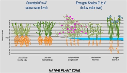
Seed mix specifications are a key to the success of any restoration or native planting project. When choosing a seed mix, the combination of species should be suited to meet existing site conditions. The plant and shrub species that excel in moist / saturated ground conditions are not going to be the same species that thrive in upland / dry ground conditions. To determine what forbs, grasses, and tree / shrub plantings are best suited for an existing environment, a good reference to use is the Michigan National Shoreline Partnership’s Plant Zones. The first three zones are plants that are associated with aquatic and wetland habitats while the fourth zone has plants associated with an upland habitat. Additionally, information on the amount of light, plant height, bloom time and color, special adaptive features, and salt tolerance level are included.
Bloomfield Township promotes the use of native plants for innovative or restorative projects. This is because native plants are best adapted for providing the root structure needed to stabilize shorelines or slope stability, and are also already adapted to the site and climatic conditions in their natural habitats. In addition, there are many animals, birds, fish, and other wildlife that are dependent upon specific native plants for their survival. The use of native plants is important and should be considered when planning a landscaping project.
Frequently Asked Questions
1. How do I know if I have wetland on my property?
The new wetland inventory maps are a good starting point by showing the general location of wetlands in Bloomfield Township. However, because of the scale of these maps and the methods used to produce them, they cannot be used to accurately define the location and boundaries of wetlands on an individual parcel of land. The DEQ provides a service for identification of wetland locations and boundaries. Please see the DEQ Wetland Assessment Program webpage for more information.
2. How were the wetland inventory maps created?
The wetland inventories were created by compiling information from:
- Existing Bloomfield Township wetland data
- Michigan Center for Geographic Information
- Oakland County wetland data
- Michigan Natural Features Inventory
3. If the inventory maps do not show the location and boundaries of wetlands on my property, what is their purpose?
Knowledge of the general location of wetlands is useful to support land use planning and zoning, watershed planning, wildlife and resource management planning, and similar uses. Individuals and businesses seeking lands for particular purposes can use the wetland inventory maps as initial screening tools where known wetlands should be avoided. The wetland maps can also be used to help highlight areas where wetland restoration can provide benefits to fish and wildlife or help to protect other water resources. Over time, help state and federal agencies track the status and trends of wetland resources on a regional, state, or national basis.
Additional Information
Please contact the Bloomfield Township Engineering and Environmental Services Department if you have questions about the material presented here. The following websites offer more information about the use of native plants in wetland areas.
MDEQ Wetland Protection
Wild Flower Association of Michigan
Oakland Conservation District
Updated: December 2017